Drone-based mapping using RTK (Real-Time Kinematics) technology is transforming the way we collect land data. Compared to traditional land surveying methods, drone mapping offers several advantages that make it a more compelling option for many projects. In this blog post, we will compare the cost per acre, time to process data, accuracy of deliverables, and legal distinctions between drone-based mapping using RTK technology and traditional land surveying.
Cost per acre
One of the most significant advantages of using drone-based mapping using RTK technology is the lower cost per acre compared to traditional land surveying. Traditional land surveying can cost anywhere from $500 to $5,000 per acre, depending on the complexity of the terrain and the location. The cost of drone-based mapping can range from $20 to $200 per acre, depending on the size of the project and complexity of deliverables. This cost advantage makes drone mapping an attractive option for many projects, especially for projects with complex, unsafe or otherwise inaccessible terrain that may not have been feasible using traditional surveying methods.
Time needed to process data
Another significant benefit of drone-based mapping is the speed at which data can be processed. Traditional land surveying can be a time-consuming process taking weeks or months to process, while drone mapping can be completed in just a few days. With the use of specialized software, drone data can be processed quickly and efficiently, providing accurate 3D models of the terrain. This fast turnaround time means that project timelines can be reduced, and decisions can be made faster. Mission parameters can also be saved to duplicate flights for follow-up data collection. This is useful for before and after comparison as well as project progression reports.
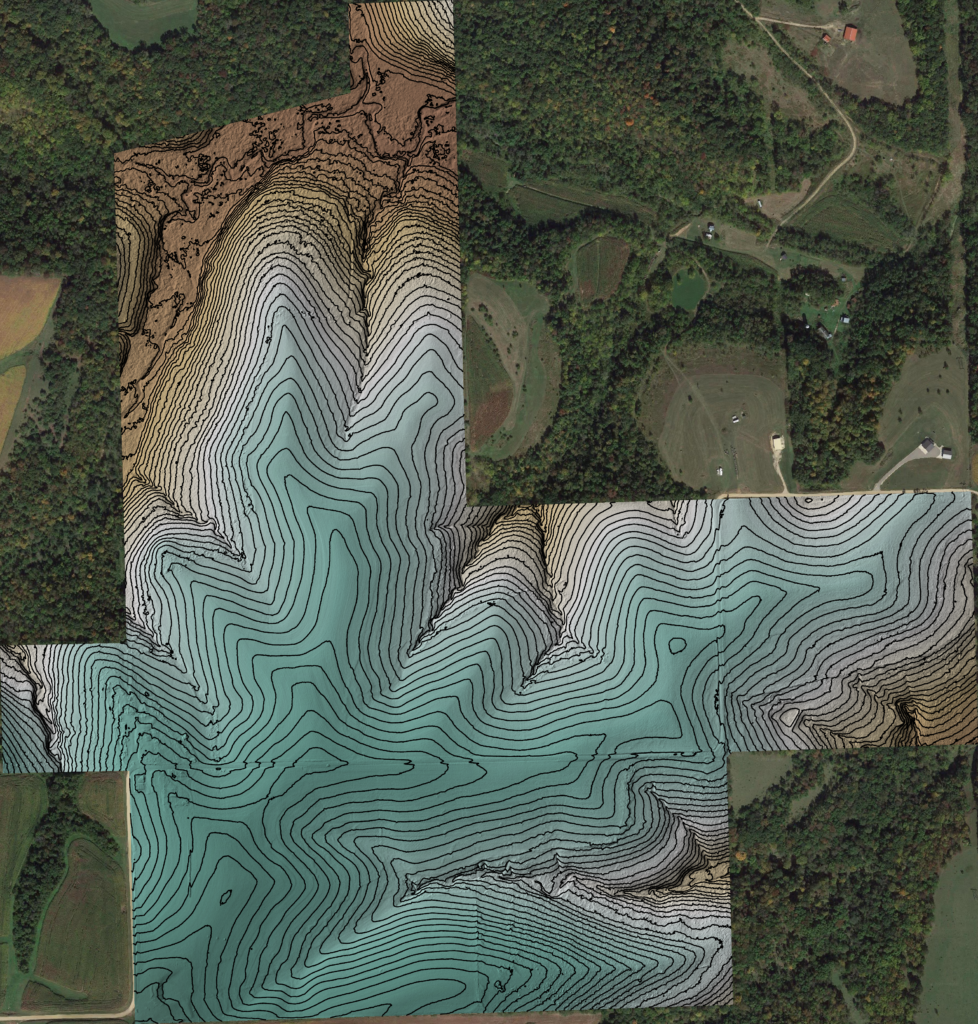
Accuracy of deliverables
When it comes to accuracy, drone-based mapping using RTK technology can achieve highly accurate results comparable to traditional land surveying. In fact, drones can achieve centimeter accuracy with the use of RTK technology, making them a viable alternative to traditional surveying methods. Additionally, drone mapping can provide high-resolution imagery, allowing for detailed and accurate analysis of the terrain.
Legal Distinctions
In terms of legal distinctions, traditional land surveying is considered to be the more authoritative source of land data due to the strict regulatory requirements and licensing of land surveyors. While drone-based mapping is a relatively new field, licensed professionals can still carry out drone mapping and adhere to strict industry standards resulting in highly accurate deliverables. Additionally, drone data can be certified by qualified surveyors, ensuring its accuracy and legal compliance.
What is right for you?
Drone-based mapping using RTK technology offers several advantages over traditional land surveying, including lower cost per acre, faster data processing times, and comparable accuracy. Ultimately, the benefits of drone mapping make it a compelling option for many projects, particularly those that may have been too costly or time-consuming using traditional methods.
For reliable, safe and cost-effective drone mapping services, contact The Drone Company today! Let us show you why we’re the top choice for drone-based mapping services.